
As part of the Bay Crossing Study (BCS) National Environmental Policy Act (NEPA) process, a Range of Alternatives was developed based on previous studies and planning documents; input from Federal, State, and local regulatory agencies; and public comments. A No-Build Alternative, four Modal and Operational Alternatives (MOA) and fourteen Corridor Alternatives were identified. An Alternatives Screening Process derived from the Study’s Purpose and Need was used to evaluate and refine the Range of Alternatives to the Corridor Alternatives Retained for Analysis (CARA) which were carried forward for detailed analysis in the Tier 1 Draft Environmental Impact Statement (DEIS).
Alternatives Development Timeline
Spring 2018 –
Spring 2019
- Spring 2018 Public Meetings
- Identify Range of Alternatives
- Conduct initial environmental inventory
Summer 2019 – Winter 2019/2020
- Screen Range of Alternatives by applying screening criteria
- Fall 2019 Public Open Houses
Spring 2020 –
Winter 2020/2021
- Analyze the Corridor Alternatives Retained for Analysis
- Publish Draft Environmental Impact Statement (DEIS)
Spring 2021
- Spring 2021 Public Hearings
Range of Alternatives
No-Build
The No-Build Alternative includes existing infrastructure, all currently planned and programmed infrastructure projects as of Project Scoping in 2017 and regular maintenance at the existing Bay Bridge. As noted in the Purpose and Need, the existing bridge experiences extensive congestion today. Maintenance activities and incidents contribute further to that congestion. Analyses demonstrated that these conditions were expected to worsen in the future, as traffic volumes continue to grow.
Modal and Operational Alternatives (MOA)
The MOA include other modes of travel such as ferry and transit, as well as improved operations at the Bay Bridge and on the existing roadway network. The following four MOA were identified:
Transportation System Management / Travel Demand Management (TSM/TDM)
TSM/TDM consists of infrastructure and operational changes to improve operations of the Bay Bridge and existing roadway network without adding major new capacity. Improvements could include variable tolls, changes in the reversible lane operation at the existing Bridge and/or other similar strategies.
Ferry Service
Ferry service could include one or more sets of ferry terminals to connect the Eastern Shore and Western Shore as well as roadway improvements to connect the terminals to existing roadways.
Bus Rapid Transit (BRT)
A new BRT service between major destinations on the Western and Eastern Shores was considered. BRT is a high-quality, express bus service with features that enhance convenience, reliability, and travel times compared to typical bus services. It was assumed that the BRT service would use the existing Bridge to cross the Chesapeake Bay.
Rail Transit
A new rail line and implementation of a new rail service between major destinations on the Eastern and Western Shores was also considered. It was assumed that a new Chesapeake Bay crossing would need to be constructed to carry such a rail line across the Bay. The Rail transit alternative would include consideration of both Heavy Rail Transit and Light Rail Transit.
Corridor Alternatives
The development of Corridor Alternatives included a broad geographic area to identify a reasonable range of corridors throughout the full extent of the Chesapeake Bay in Maryland, over 100 miles from north to south. The MDTA identified 14 Corridor Alternatives, which are approximately two miles wide and vary in length. Each extends from a freeway or major state highway on the Western Shore to US 301, US 50, or US 13 on the Eastern Shore.
The fourteen Corridor Alternatives run generally perpendicular to the shorelines, connected to peninsulas or long stretches of Chesapeake Bay shoreline, and avoid mouths of rivers or other large bodies of water where possible. The corridors are also generally located to avoid towns and developed areas where practical.
| Corridor Alternative | Location/Description |
|---|---|
| Corridor 1 |
|
| Corridor 2 |
|
| Corridor 3 |
|
| Corridor 4 |
|
| Corridor 5 |
|
| Corridor 6 |
|
| Corridor 7 |
|
| Corridor 8 |
|
| Corridor 9 |
|
| Corridor 10 |
|
| Corridor 11 |
|
| Corridor 12 |
|
| Corridor 13 |
|
| Corridor 14 |
|
Corridor Alternatives Map
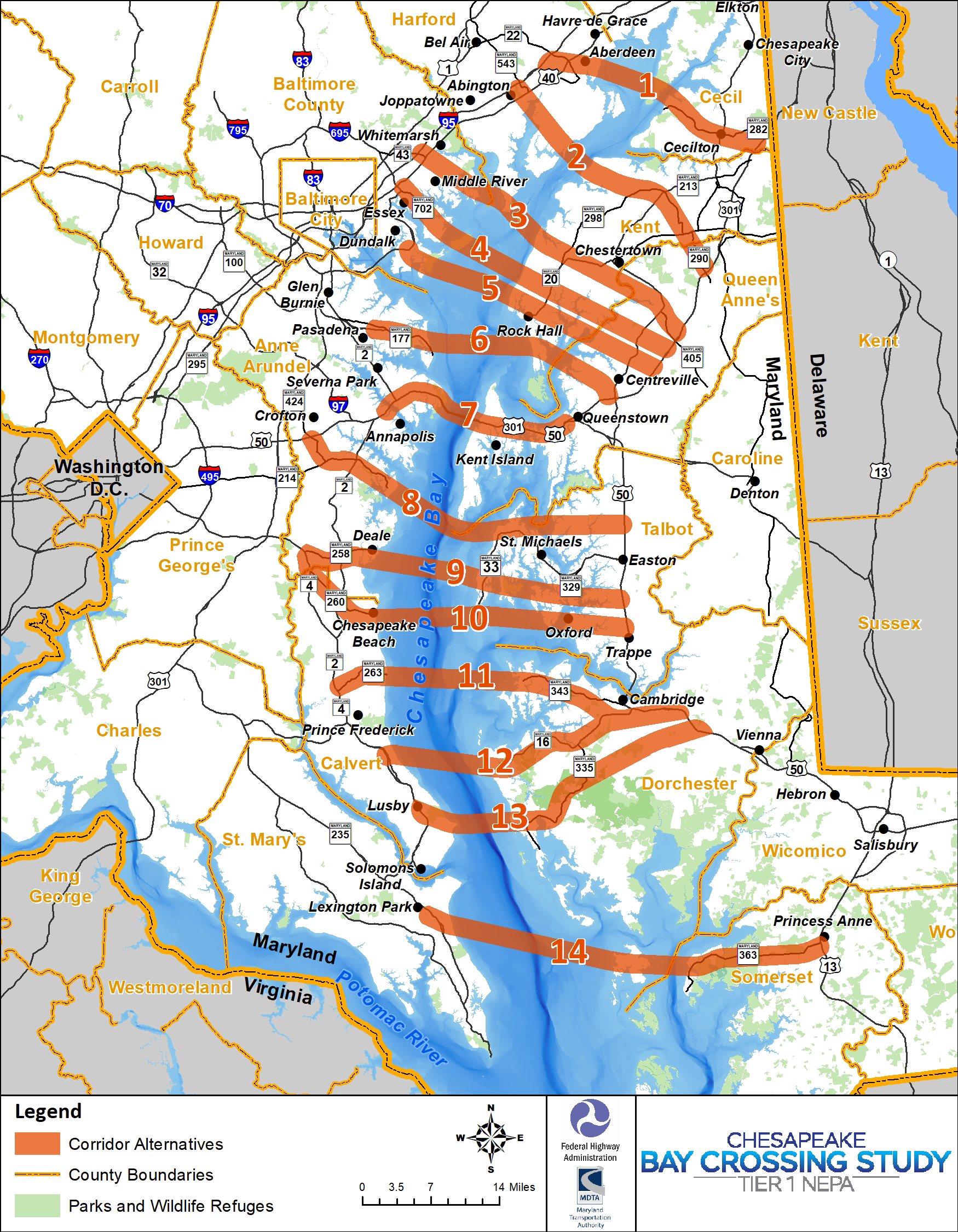
To englarge the map, click anywhere on the preview image above.